Themes
Integration of GIS solutions into all steps of the project planning cycle:
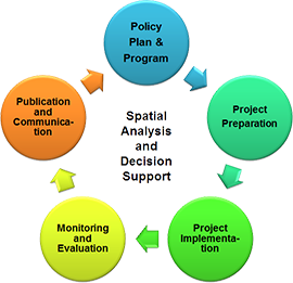
Policy, Plan and Program: Ex-ante preview of the spatial outcomes and implications of development visions using scenario-driven demand models.
Project Preparation: Support sustainable allocation and sequencing of projects through spatial-multi criteria assessments.
Project Implementation: Zonation and land management support through participatory GIS, surveying and land suitability assessments.
Monitoring and Evaluation: Assessment of key environmental, socio-demographic and economic performance indicators using remote sensing, thematic models and statistical surveys.
Publication and Communication: Efficient information distribution and involvement of stakeholders through online, interactive geodatabrowsers.
Spatial Toolbox
Focus is on methods and tools that deliver reliable results in data scarce environments and that can easily be adjusted to the conceptual and technical capacity of the client.
Desktop RS/GIS
Web-GIS and API's
Database and Web-IDE's
Applications
Strategic Environmental Assessment (SEA) of the Quang Nam Province Land Use Plan 2011-2020, Viet Nam
Strategic Environmental Assessment (SEA) of the Power Development Plan VII, Viet Nam
Strategic Environmental Assessment (SEA) of the Power Development Plan VI, Viet Nam
Strategic Environmental Assessment (SEA) of the Greater Mekong Subregion (GMS) North-South Economic Corridor Strategy and Action Plan (NSEC-SAP)
Strategic Environmental Assessment (SEA) of the Tourism Sector in Cambodia
Carbon-Neutral Transport Corridor (EWEC) Feasibility Study
Spatial Multi-Criteria Assessment of potential areas for rubber plantation in Southern Lao PDR
Greater Mekong Subregion Interactive Atlas of the Environment Operations Center
Greater Mekong Subregion Development Maptool of the Environment Operations Center
Environments of the Poor - Geodatabrowser of the ADB Regional Sustainable Development Division
Health Facility Maptool of the Papua New Guinea National Department of Health (NDOH)